Motivation for a trip to the Reserva Nacional Lomas de Ancon…. trip summary by Mike Douglas
For some time I had been interested in the distribution of vegetation along the arid coasts of Peru and Chile. This was an outgrowth of interests in succulent plants (e.g. the Copiapoa cactus of coastal Chile) and a long interest in bromeliads such as those of the genus Tillandsia – that are sort of an indicator of “tropical” conditions at the fringes of the extratropics. Tillandsia recurvata, for example, is found from central Baja California and SE Arizona, to the Big Bend region of Texas and across to Florida. Spanish Moss, Tillandsia usenoides, is found even farther north in the southeastern US. At their southernmost extreme, other Tillandsia species occur in central to northern Argentina.
Besides my botanical interest in Tillandsias, I had been generating cloud climatologies of various parts of the world and was familiar with the stratus cloud climatology along the Pacific coast of South America. I had identified patches of Tillandsia along the coast (Fig 1) and tried to relate their distribution with the presence of stratus cloud – but with limited success.
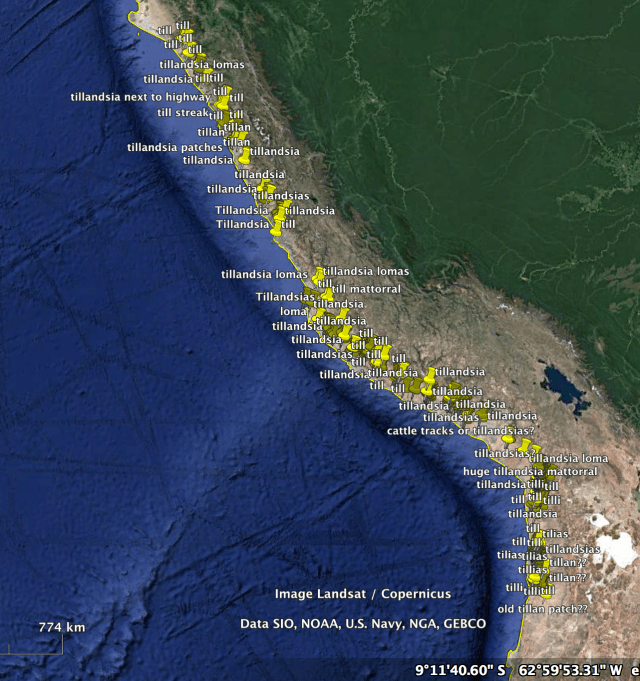
Fig 1. Some locations of Tillandsia patches or bands along the coast of Peru or northern Chile.
In the process of using Google Earth imagery to find where Tillandsia patches were present (download kmz file for Google Earth) I noted that the Tillandsia very frequently grew in bands that appeared perpendicular to the wind direction (as indicated by the sand dune orientation). Figure 2 shows such bands. Such bands were also present in the Reserva Nacional Lomas de Ancon (Fig 5). My interest in seeing these bands and examining their orientation relative to the slope and probable wind direction was one of my motivations for visiting the reserve. An online video about the reserve, showing what could be seen from the ground, was also motivation for a visit, since it was apparent that various cacti were also found there. Considerable interest has been generated by this banded vegetation, some publications related to Tillandsia bands can be found here.

Fig 2. Example of bands of Tillandsia (latifolia?) south of Lima, Peru. Chicken houses are in the lower right; the graphic scale (lower left) is 233 m. Click on image for larger view.
Our Saturday visit to the Reserve
Since I was in Lima to teach a course on mesoscale climate and weather to SENAMHI personnel and a few others, our outing was arranged for a Saturday (Dec 9, 2017). The outing was organized by José Manuel Fernández Zeballos (Manolo for short), President of SPECS (Sociedad Peruana de Cactus y Suculentas), the Cactus and Succulent Society of Peru. We had contacted SPECS before traveling to Lima, as almost 20 years earlier we had traveled with Carlos Ostolaza, then SPECS President, to a canyon (Tijeras) near Lima to see cacti.
Showing the value of Facebook pages, we had earlier contacted the Director, Haydee Palomares, of the Reserva Nacional Lomas de Ancon (via their Facebook page) to determine how to visit the reserve. She told us of the procedure to follow and also mentioned that a 4 wheel drive vehicle would be needed (due to deep sand). We mentioned this to Manolo, who we had contacted via information on their Facebook page and he made the arrangements to obtain the 4×4 with driver.
After a long drive through Lima traffic we arrived at the headquarters of the Reserve in the desert north of Lima. It turns out that we had visited this location in 1997 to train observers at the Instituto Geofisico del Peru to make pilot balloon observations prior to the big 1997-8 El Niño event. After an interesting discussion with the Reserve’s staff we proceeded north a few km towards the Reserve boundary with two guardaparques (park guards) to enter the reserve. The actual Reserve has a large semi-protected area (Parque Ecologico Nacional Antonio Raimondi) as a buffer on the south side – this buffer area borders some developed land. Squatters, hoping to obtain land titles, are the main threat to the protected areas.
Our group consisted of a Botany Professor, Dra Mercedes Francisca Gonzales De La Cruz, Manolo Fernandez (the SPECS President (who runs an environmental consulting firm), one of the three regular Guardaparques for the Reserve (Environmental Engineer David Josue Fuentes Mamani), a volunteer Guardaparque (Moises Omar Ledesma Hernandez coming from a degree program in Ecotourism) and Rosario and I.

Fig 3. Google Earth image of the region of the Reserva Nacional Lomas de Ancon, (green boundaries) with text describing various geographical aspects. Note the scale in the lower left.

Fig 4. Google Earth oblique view of the Reserve area. Small markers are GPS positions taken during our hike. At the bottom of the image are the outskirts of the town of Ancon, north of Lima.
Initially, very few plants were visible along the broad sandy valley floor. Eventually as we slowly climbed we saw sand-covered evidence of mostly-dead Tillandsia mats. Farther on we began to see scattered Tillandsia’s and widely spaced cacti of the genus Haageocereus. The road then traveled along a wash – evidence that water had flowed at times in the past.Where we stopped to start walking, there were several cacti species (Haageocereus, Mila and sparse Loxanthocereus) and three Tillandsia species (T. palacea, T. purpurea and T. latifolia). All of these plants became more numerous as we slowly climbed along a faint trail that followed the canyon bottom – roughly along a wash that showed some evidence of water passage.

Fig 5. Our approximate hiking route up the canyon from the area where the vehicle was parked. We went a bit farther than shown here by the dashed line. Note that we did not walk through the areas of the most distinctive Tillandsia bands – these were apparently to the north (left in the image above) only a short distance.
As we were visiting during the start of the dry season (at least with fewer low clouds than the May-October period) we saw no water. But the upper reaches of this canyon, known as Barranca de los Innocentes (Innocent’s Canyon), are at 1800m (almost 6000ft elevation) so summer (Dec-April) showers might be responsible for some of the water erosion in the lower wash we were traversing (we were walking between 1600-1900 ft elevation). The month of March 2017 was very wet along the western Andean foothillls and coastal northern Peru, associated with a “coastal El Niño” event with much above normal ocean temperatures, so these interment events may be responsible for the fluvial erosion that we saw evidence of. Alternatively, heavy fog drip from the persistent winter low clouds might saturate the soil and cause the runoff in the wash – though not likely to be of “flash flood” proportions.

Fig 6. An arroyo (or wash) where water had recently run strongly enough to remove any vegetation. Whether this was due to showers in the mountainous “headwaters” or persistent fog drip over the drainage for a multi-month period is not clear. Photo by Rosario Douglas – all photos on this page are either by Mike or Rosario Douglas.

Fig. 7 Another view of the wash farther up, showing vegetation along the “banks” of the wash. The main cacti evident is Haageocereus pseudomelanostele and the Tillandsia is T. latifolia.

Fig. 8 A Haageocereus that was apparently uprooted and carried downstream when water was flowing…
Not surprisingly, I was initially most fascinated by the Tillandsia’s that we started to see more densely and in better condition as we slowly ascended the wash terrain. There was a path of sorts where others had walked previously, but hardly a well beaten path – which was good since the dirt roads where vehicles had traveled were pulverized with fine dirt and sand.
The Tillandsias
There were three Tillandsias along our route, though they usually didn’t occur all in the same place. The largest plants were Tillandsia latifolia which tended to be greener than the other species and had new plants developing from some of their flower stalks.


Above: A mosaic of Tillandsia latifolia images. Click on any photo to start the sequence.
The mid-sized Tillandsia species was T. purpurea, these were silvery whitish and formed clearly defined bands.


Finally, the smallest-leaved Tillandsia was T. palacea. These formed extensive bands on the hillsides, but were less abundant on the flatter areas that we were walking on. Their leaves, to a non-specialist like myself, were roughly similar to the very widespread Tillandsia recurvata (not present in the Reserve – at least where we went).


Now for the quiz: can you identify the three Tillandsia species in the image below? Click on the image to see a larger version first.

Find the three Tillandsia species in this photo. Here is the answer.
And in the image below – can you spot the three different Tillandsias? Click on the image to see a larger version first.

Three Tillandsia species on a slope. Do you know your Tillandsia’s? Answer is here.
Tillandsia bands


The Cacti
The cacti, which became increasingly apparent as we climbed, included Haageocereus (Espostoa) pseudomelanostele, which was by far the most abundant species. Some plants were in bud – about to flower, but most were not.


Second in abundance were the Mila caespitosa, these were not only small, but generally ugly. Except for the occasional bright yellow flowers on some plants!


Then, much less common, there were some Cleistocactus (Loxanthocereus) acanthurus with bright red flower slower down near the vehicle, though we might have easily missed plants anywhere along the walk. Our sampling was far from extensive in the 2 hours scrambling along the wash environment.


Finally, at the higher parts of our walk (and more common yet higher up – from our guide’s comments) we saw the larger plants of Neoraimondea arequipensis. This large columnar cactus is found from nothern Peru to almost the Chilean border at lower elevations. (We have seen it above sea cliffs on the road top Arequipa in southern Peru.)


Though we saw very few plants that were not Tillandsia’s or cacti, here is one (below) by a wash – that presumably had access to more reliable water – or perhaps it was just one wet season’s growth (?)
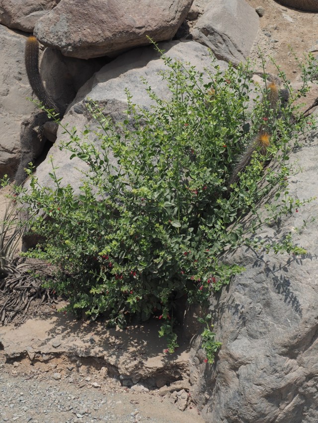
shrub along the wash
Fauna that we saw
Interesting fauna seen included a lizard, a few birds and some smaller insects. The lizard is shown below.


Photos of the participants
All in all, it was a very fruitful trip, not only with many interesting plants and landscapes but a great deal of interesting discussions among all who participated.

Mike Douglas with Haageocereus and Tillandsia

Everyone but the photographer and driver… returning down the wash

The driver with the vehicle. Note the Tillandsia’s being most numerous near the crest of the hills – greater fog drip with the stronger winds?

The Guardaparque (ranger) David Josue Fuentes Mamani (left) and Manolo Fernandez (right)

another view of the group… the volunteer ranger Moises Ledesma Hernandez is on the far left.

The ranger (David Mamani), Manolo Fernandez and Rosario Douglas discussing something profound (?)

Descending the wash, surrounded by Haageocereus…

back at the vehicle, a sunny day now at the upper reaches of the canyon.

Why do we find all of this interesting??
