The 2019 Chilean-Argentinean eclipse
This page has been prepared very recently since there is (to me) a surprising amount of interest in the next solar eclipse in Chile and Argentina – which is 18 months away at this point. Our first total solar eclipse was from near the beach south of Mazatlan, Mexico. That eclipse was almost 7 minutes long – so to a certain extent, every other eclipse will be downhill. However, our second total solar eclipse, last year in Wyoming, was spectacular, despite its shorter 2.5 minute duration, so I do understand the interest. Seeing comments on eclipse forums motivated me to put together this material related to the 2019 eclipse.
My wife and I have traveled to Chile a number of times (she was born there) and we have explored the country (mostly north of Santiago) in the pursuit of succulent plants, birds, volcanoes and the likes. That is why I encourage people who are considering traveling to see the eclipse to look past the vineyards of central Chile, and head farther north – to the land that many Chileans themselves don’t think much of. The Atacama is one of the few areas on Earth where wind erosion dominates the weathering processes, and you will see landscapes that are very similar to Mars. If you bring a small telescope (we have carried up to a Celestron Nextstar 8″ via checked luggage -suitably packed of course) you will see many new features of the night sky – assuming you live in the Northern Hemisphere. Away from the coastal low clouds the skys are very dark. Unfortunately, the summer Milky Way will be affected by solar glare in July.
But to us, the other natural aspects of the Atacama region are what we find most interesting. These range from the coastal low cloud belt that has a unique succulent flora, to the high Andes volcanic features (perhaps the best place on Earth to see some volcanic landforms because of the lack of erosion, vegetation or clouds). Then there are the high altitude dry lakes (salares) and marshes (bofedales) that have up to three species of flamingos, other unusual birds, and vicuñas and guanacos. Check the links below, especially our two talks, to get a flavor for this region. And self-driving is quite feasible outside of the busy region of central Chile – from the main international airport just drive north – avoiding most of the congestion. If coming from the UK, you will have to adapt to driving on the other side, but for most everyone else (except Aussies, South Africans etc) there won’t be that “transition”.
A Google Earth kmz file shows the 2019 Chilean eclipse path and the mean cloudiness for the winter season (May-Oct mean daytime (near noon) cloud frequency). (Please download the file and open in Google Earth… that seems to work better than trying to open the kmz file directly. Of course, you need to have Google Earth installed on your computer – it is free.)


What you will see is something like the images below:
I put a couple of yellow pins on areas that ought to be the best for viewing – in terms of minimum cloudiness. Also, the roads, at least in Argentina, should allow some maneuvering at the last minute if necessary (not ideal).
The eclipse will be late in the day so low clouds will probably be less, but the same general patterns associated with the topography should remain. Being mid-winter, conditions will be cool and you have a fair probability of the sun being obscured by mid-high clouds associated with extratropical low-pressure systems… Having said that, if you have decided to see this eclipse, be sure to plan to visit Pan de Azucar National Park and other locations along the coast to see the rich succulent plant flora. Just south of La Serena is Fray Jorge National Park – a small patch of forest that is a few hundred km north of other coastal forest – because it is immersed in low clouds/fog for many days each year. This fog contributes to sustaining a small forest patch that would otherwise not be present at this latitude. You could do this on a day trip out of La Serena while waiting for the eclipse. Probably every hotel in La Serena will be booked solid, so think about reservations or alternatives (like camping) now. You can always drive much farther north, to around San Pedro de Atacama, to see impressive volcanoes and salt lakes with flamingoes etc, or even farther north to near the Chilean border to visit Lauca National Park… Though the eclipse would obviously be a highlight of a trip to Chile, I would plan my trip around non-eclipse related aspects of the region, with a couple days set aside for you to be where you want to be for the eclipse date. I would definitely not put all my eggs in the eclipse viewing basket!
To see some of the landscapes of the region check out the two talks (Chile-Argentina 2009-10) by going to our webpage: https://thetravelingnaturalist.org/concise-talk-list/ and scrolling all the way down. The two talks illustrate natural history aspects of the region… on both sides of the Andes.
Of course, you might be aware that cloud conditions will be more favorable east of the Andes, in Argentina… and you might have more room for driving during the last few hours. There are things to see there also. But the farther east you go, the lower the sun will be to the horizon and the shorter the eclipse duration.
To get a feeling for the variability of cloudiness, day to day, check this satellite imagery site out and look at the past winters… https://worldview.earthdata.nasa.gov Be sure to zoom in to the proper part of the Chilean coast
I have saved the reader a bit of effort and produced a mosaic that shows the cloudiness at 130PM local time on July 2 for the past 14 years – over the Chilean coast and western Argentina – along the eclipse path. The mosaic is below (be sure to click on the image to see a large version). The blue line is the eclipse centerline (the lines are approximate…)
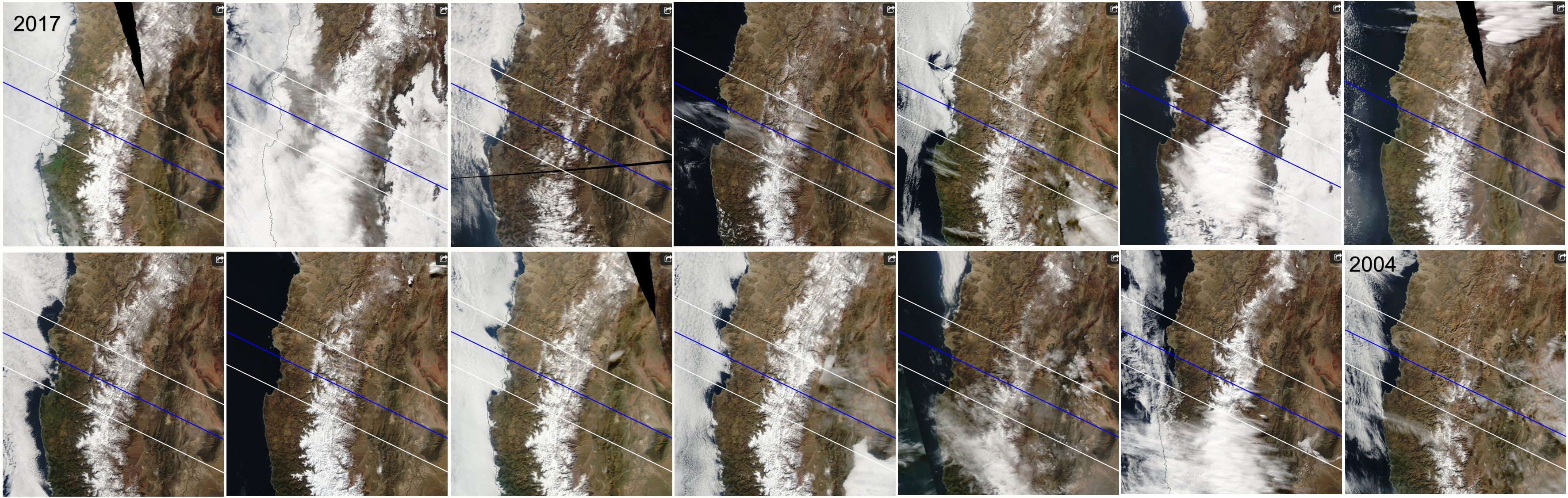
Cloudiness for each July 2 from 2004 to 2017 to show the variability of cloud cover that one can expect for the eclipse date (July 2 2019). Note that the white band running up-down (N-S) through the middle of the images is mostly snow cover over the higher Andes – not cloudiness.
The result was a bit surprising to me – as it shows that inland from the Pacific coast and before you reach the Andean snows, something like 12 of the 14 years were cloud free (I expected more wintertime clouds). East of the Andes, over Argentina, most days were clear – except for days associated with winter cold surges and the presence of solid low clouds (perhaps 2-3 days out of 14). This is hardly a careful statistical evaluation of cloudiness but it should give the reader an idea of the cloudiness variations that might be expected. And cloudiness along the Chilean coast is primarily low clouds (stratus) so by climbing up in elevation you can climb above these low clouds. Unfortunately, there are not many paved roads in this region to do this – the Pan American Highway stays low. There are dirt roads that go to mines or small towns, but access might be an issue.
If you want further info don’t hesitate to email me (Mike Douglas) at douglasnoaa@gmail.com Also, don’t hesitate to explore the rest of our website! I have been an amateur astronomer since elementary school – but I am interested in many other aspects of natural history. Expand your horizons…
