During October 9-26, 2015, my husband (Mike) and I (Rosario) participated in a succulent plant tour in Madagascar. This trip log is intended to provide both visual and written information about our experiences during this trip. We have also added comments, conclusions, recommendations and a reference list that may be of use to travellers planning a visit to Madagascar.
Important note to the reader
Our trip report is not a blog. Blogs tend to be written quickly and are usually short. Our trip report has taken several months to put together, includes hundreds of images, and has many links to references. There are many reasons for all of this. Firstly, prior to our trip we had difficulty finding enough travel images and detailed information related to the areas we visited. We knew that many people had visited Madagascar with the intent to see succulents, but the availability of detailed trip logs seemed to be in short supply. Secondly, after our trip, we wanted to dispel any romantic misconceptions that foreigners might have about Madagascar – some induced in part by the Disney movies about Madagascar. Thirdly, we wanted to provide a web source of natural history information for individuals who might be considering tours to the parts of Madagascar that we visited. We have also provided our perspectives on what good tours should have – and what ours lacked.
All comments in this log reflect our personal opinions. All comments in this log where the word “I “or “my” are used refer to myself (Rosario). Although I did most of the writing, the text has been revised extensively by both of us.

Our Trip
Because of the long distance required to travel to Madagascar and the possibility of visiting western South Africa during the springtime (a good time to see the succulents before they dry out too much and to see some flowers) we decided to combine our trip to Madagascar with a visit to South Africa. This was aided by the fact that the lowest-cost flights from our location (and most direct route) to Madagascar was via Johannesburg, from which there were daily South African Airways flights. We both enjoy traveling and exploring in South Africa and this was to be our 6th visit since 2002 and our second visit of 2015. Thus we flew to South Africa in early September and spent about a month visiting Namaqualand, the Little Karoo, the Cape area and interior fynbos, as well as farther into the interior (Augrabies and Mokala National Parks). Then we flew to Madagascar and at the end of our Madagascar tours we flew back to Johannesburg. We then spent another 16 days visiting Kruger National Park and its vicinity where, aside from the numerous mammals, we were hoping to see a good variety of birds, including recent arrivals from Europe. It was our third visit to Kruger.


Since our succulent plant tour itinerary was focused exclusively on the dry forest environments, we decided to also schedule a shorter tour to moist habitats in eastern Madagascar primarily the Andasibe-Mantadia National Park area. The main objective of this second tour was to see moist forest environments. In the end we spent 27 days in Madagascar between the two tours. Included in this trip log is a section called Private tour where you can read about our second tour in Madagascar.
Photography comments by Mike
We traveled from South Africa with 4 cameras – seeming overkill for the two of us. And that excludes one camera we left in South Africa! However, experience had taught us that some redundancy is useful. Two cameras were “mirrorless” Olympus OMD EM1’s; by the end of the trip one had mostly failed in an important regard; hence the value of the back-up. These Olympus cameras have the advantage of a tilting rear viewfinder allowing composition of subjects when the camera is on the ground or over your head. However, they do not have GPS location capability, hence the need for another camera, a Nikon D7100 with a newly purchased 18-300mm zoom lens. It turned out this lens, despite my dislike of all-in-one lenses, was critical during our many short stops where frequent lens changing would have taken too much time and allowed dust to land on the camera’s sensor. For example, I would need to shoot a wide-angle shot of a tree, then zoom to shoot a bird on the tree. Then a lizard on the ground… The zoom gives you flexibility to do this. (You can see I am trying to justify to myself the $1000 we spent on the lens.) The Nikon D7100 is also compatible with a GPS unit I have, so we could obtain locations for later comparison with Google Earth imagery. Finally, we brought along a new Olympus TG-4 point-and-shoot camera for quick and candid photos of people and places where our larger cameras might attract unwanted attention. It was also waterproof and had a build-in GPS capability so we could also get positions from this camera. The quality of the images is not very good, but many times any photo was better than none at all. Many of the roadside photos and “people pictures” were taken with this camera – there were few opportunities for “controlled” photos of such scenes.
We put all our images in Aperture (we work with Apple computers) and modified as required. Many are still not great, even after modification, but are used here because they provide important documentation of key events. Finally, to put the images into this website we scaled the images to 1280 pixels across and exported them from Aperture as jpeg files. Thus, some images might be 6000 pixels across in the original, but are reduced to 1280 pixels for display here. By clicking on the photos you can see larger versions – usually 1280 pixels across. We could have put full-resolution versions online in this manner – but the space allotment for our WordPress account would have been quickly used up. Such are the compromises of website displays.
Finally, in addition to the cameras, we brought a hand-held ETREX GPS unit where we recorded positions from time-to-time. This served as a back-up and allowed us to mark our daily route, even if we were not taking many photos.

Collectively, the positions from the two digital cameras and the Garmin ETREX gave us enough points to produce fairly detailed route maps, especially in the maze of dirt roads that crisscross the west coast of Madagascar. More comments about photography are given in the recommendations section.
Why go to Madagascar?
As succulent plant enthusiasts we have been aware for a long time of the remarkable diversity of succulent plants found in Madagascar. Many iconic succulents such as Adansonia grandidieri or giant baobab are found nowhere else. A visit to Madagascar was in the back of our minds for a long time. You can read an interesting review of the different succulent plant families, current threats and conservation plans here.
We have generally been independent travelers, preferring the freedom to design our own itineraries and the flexibility that such type of travel provides. However, not being perfectly fluent in French, not speaking Malagasy and not knowing where to see the best succulent plant habitats, we decided that a succulent plant tour would be the best option for visiting Madagascar for the first time. Our experience with tours had been limited to a couple of week-long private tours in Ghana, and a trip to eastern Brazil in 2009 with South America Nature Tours (SANT hereafter) a one-person company run by Guillermo Rivera.
Our online searches yielded a fair amount of information about Madagascar tours offered by both local and international tour operators. Few nature tours to Madagascar focus on the plants, with birds and lemurs tending to be the main subjects. Other tours concentrate on either adventure tourism, or time at beach resorts. In the end, given that specialized succulent plant tours to Madagascar are infrequent and not routinely offered by tour companies, we decided to take a tour being offered by SANT in October 2015. This despite the fact that SANT had only run its first tour to Madagascar the previous year.
Prior to the Madagascar trip we were aware that conditions related to environmental protection and habitat degradation in Madagascar were not ideal. We had read books about Madagascar (see our reference list at the end), some of which clearly mentioned the problem of overpopulation, poverty and the environmental consequences. These two elements combine to exert a heavy toll on natural habitats throughout the country. However, nothing we read or heard prior to this trip prepared us for the levels of habitat degradation and the ever-present poverty we observed in Madagascar. Trip logs, traveler’s reviews, reports, travel books, National Geographic or BBC specials, articles about Madagascar often fail to convey the less ideal aspects of what travelers will see during their visit to Madagascar. Travel books and articles tend to emphasize the novel and more pleasant aspects of the country and many travelers don’t really want to admit to a less than “awesome” experience to their friends when they return home. We are aware that some tours are better than others and that the experience and customer satisfaction level can vary greatly depending on the tour you take. In our log we are trying to provide an objective narrative of what we saw and our experience with our particular tour.
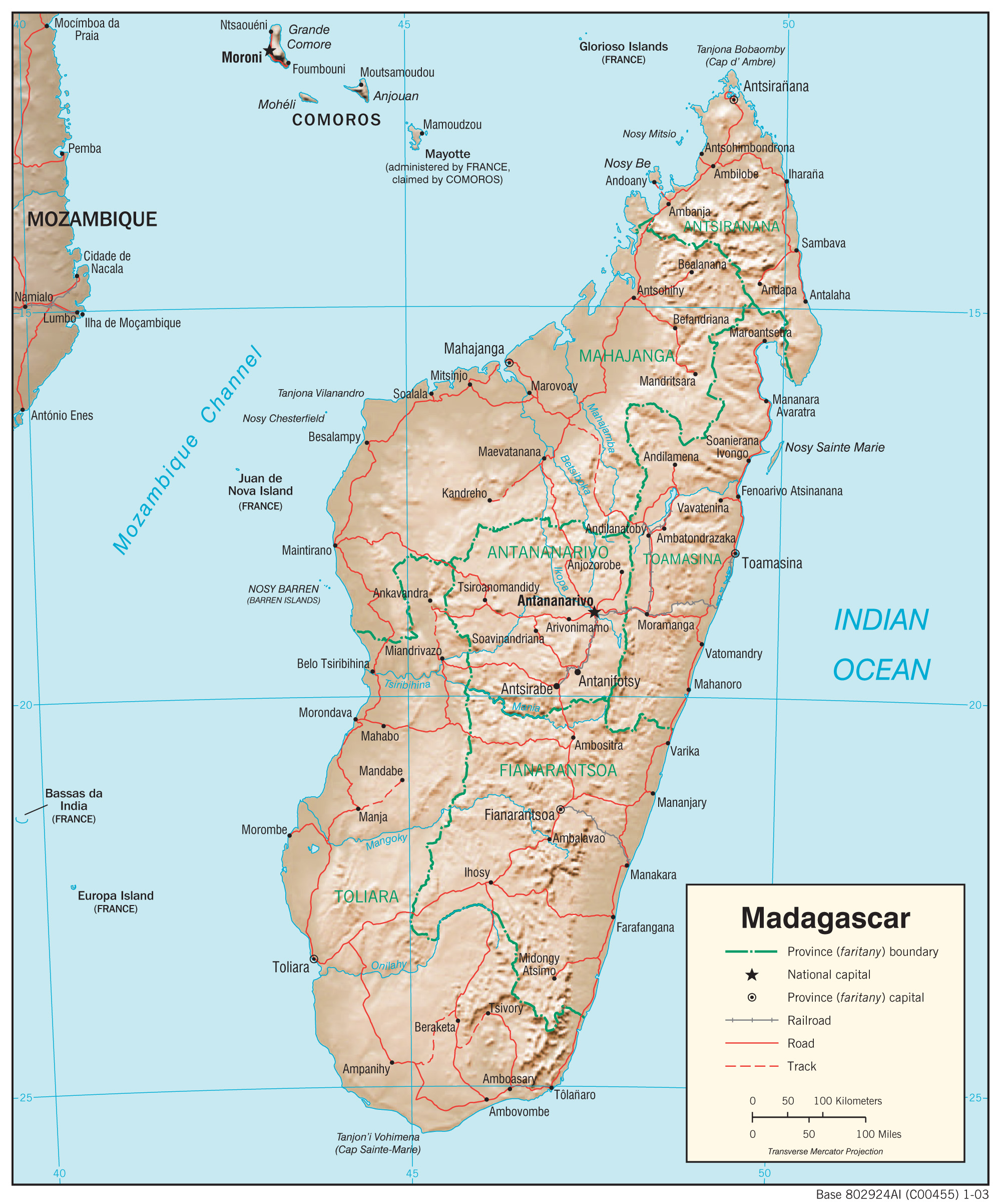
You can read the daily blogs by using the drop down menu or you can go directly to every section by clicking on the names below. A Google Earth kmz file showing where we stayed each night of our tour can be seen here.
Days 1-2 Tana to Morondava
Days 14-15 Isalo to Fianarantsoa
Days 16-18 Fianaratsoa – Antsirabe to Tana
Private tour Days 1-3 Tana-Ambohitantely Reserve-Tana
