Introduction to Baja California
This page describes some of the natural aspects of the Baja California peninsula. One of us (MD) has been traveling through Baja California since 1972 or so – before the entire peninsula was connected by a paved road. Together we traveled the length of the Baja California peninsula in 1987, then again several times in 2004 as part of research work to establish meteorological stations for a field experiment. In 2019 we returned with two Mexican biologists to more fully explore aspects of the peninsula with modern digital cameras and with a better understanding of the flora and biogeography of the region. This website uses detailed notes and some photographs from our earlier exploration, together with material from the 2019 trip, to provide an overview of what we think are some of the highlights for the natural history traveler.
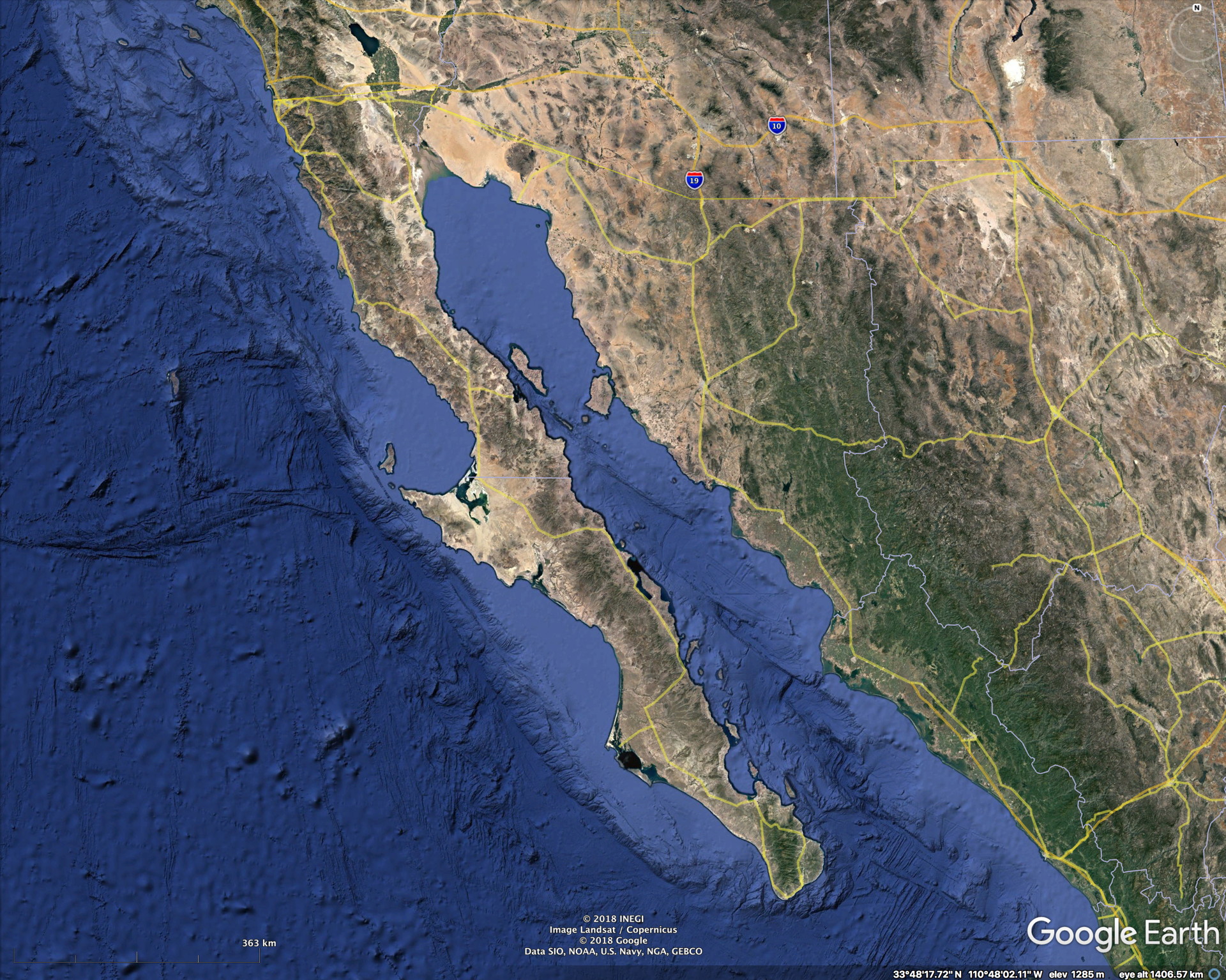
Overview maps of the Baja California peninsula are shown in Figs 1-3. Politically, Mexico’s Baja California peninsula is divided at the 28˚N latitude line into two states – Baja California and Baja California Sur. Most of the peninsula’s population resides in Tijuana (next to San Diego) and Mexicali (next to US border) in the Imperial Valley. Large towns, of several hundred thousand people are Ensenada (about 70 miles south of Tijuana) and La Paz, in the far south of the peninsula. Los Cabos and San Jose del Cabo are the main fly-in tourist destination and are at the tip of the peninsula and they have been growing rapidly in recent decades, but are smaller than the cities mentioned above.
For the long highway stretch (850 miles, 1370 km) between La Paz and Ensenada, all of the towns are relatively small. But because there is only one main N-S road connecting these towns there is steady truck and bus traffic along the route. Not by any means heavy – especially at night when it becomes very light, but sufficient to maintain an array of modern conveniences. The road is usually in good condition, but is one lane each way and with few exceptions it does not have shoulders. In fact, it is often raised above the surroundings, making it difficult to pull-off the road. More on such “details” in a later section.
Many websites discuss the touristic infrastructure along the peninsula – we mention a few of them below for travelers considering visiting the peninsula. Due to its close proximity to California, Baja California probably receives more driving tourists from the US than any other state in Mexico. For this reason there is more information available to the traveler than most other Mexican regions. The travel suggestions section covers this.
Links to specific pages
We have broken down this material into the following sections. This is the organization of our material.
Topography and geology of the peninsula
Central Baja California Desert
Summary of the peninsula’s highlights
Basic climate of the peninsula
The latitude range of the Baja California peninsula (here defined as starting in the north at the US-Mexico border) is roughly from 32.7˚N to 22.9˚N – barely extending south of the Tropic of Cancer (about 23.45˚N). In the north, winter rainfall dominates and summers are usually very dry – typical of Mediterranean climates. The farther one proceeds south, the greater the proportion of summer rain relative to winter rain. In the Cape Region (the area south of La Paz, summer rain is dominant and winters are dry. This results in a much different flora than farther north on the peninsula.
The oceans that border the Baja peninsula strongly affect the climate of the peninsula. The Pacific Ocean is relatively cool most of the year due to upwelling of cooler water from below. The Gulf of California, very shallow in the northern Gulf, undergoes a large seasonal temperature variation. It is cool in winter and spring (60˚F, 15˚C) but dramatically warms during summer and reaches 86˚F (30˚C) or thereabouts. Some typical sea-surface temperature maps are shown in Fig 5. The annual cycle of sea temperature at Puerto Peñasco, at the northern end of the Gulf, is shown in Fig 6.
Topography and geology of the peninsula
Baja California is separating from the rest of Mexico via the relative motion of the Pacific plate from the tectonic plate to the east. The geology of the peninsula itself is complex, and major granite batholiths exist both in the north of the Peninsula and in the Cape region. Older volcanic rocks are widespread in the central part of the peninsula and recent volcanic flows and cones (less than a few thousand years old) occur in a number of locations. Most evident from the main are the Tres Virgines Volcanoes near Santa Rosalia and the the cinder cone field near San Quintin. The highest terrain is in the mountains of northern Baja – the San Pedro Martir mountains reach about 10,000 ft and a relatively large area is above 2500m. A number of semi-isolated ranges extend to near 5000 ft (1500m) along the peninsula, as evident from fig 444. The highest points in these ranges can only be reached on foot. South of La Paz, the Sierra de la Laguna reaches almost 2000m and has genuine pinyon pine and oak forests on the top. It receives substantial summer rainfall. Unfortunately (or perhaps fortunately for its conservation) it can only be reached by a lengthy hike (we have not done this) and is a designated national park.
Travel strategies to see the peninsula
There are a few strategies to see the natural aspects of Baja California. For California or southwestern US travelers, driving south from California would be the most straightforward. Otherwise, flying to Los Cabos or La Paz is practical – though there is more traffic to Los Cabos than La Paz and the airfares are usually lower as a result.
If flying into Los Cabos, a rental vehicle is the best and really only means to see the natural aspects of the peninsula. Our last trip involved flying to Los Cabos, renting a vehicle there and driving north to Ensenada, where we dropped off our vehicle. We then took an Uber to Tijuana where we then flew out. Though this required a substantial one-way drop-off charge for the rental vehicle (more than $600 US in 2019) it saved an 850 mile return drive that might have taken three or more days.
A third possibility is to drive south from Arizona or elsewhere in Mexico and take a ferry that transports vehicles across the Gulf of California. Details can be found online, but in the past we have done this between La Paz and Mazatlan (Sinaloa) and between La Paz and Topolobampo (Sinaloa). There is a shorter ferry that runs between Santa Rosalia and Guaymas (Sonora) as well.
Main natural history attractions
Baja California is best known as a winter destination for Gray Whales that spend their winters and give birth to their young in select lagoons on the west coast of Baja California. Scammon’s Lagoon, Laguna San Ignacio and Bahia San Carlos are the main locations; the first two being the most popular. There are other whale (and whale shark) watching locations near Loreto on the Gulf.
The unique vegetation found in central Baja California such as near the small town of Cataviña, despite being of global interest to those with knowledge of succulent plants and botany, is not a major tourist draw. This is likely because of the distant drive (300mi, 500 km) required from the US border, the limited advertising of such landscapes, and the lack of well-defined parks, nature trails, visitor centers and the likes available for nature-oriented tourists.
Organization of our material
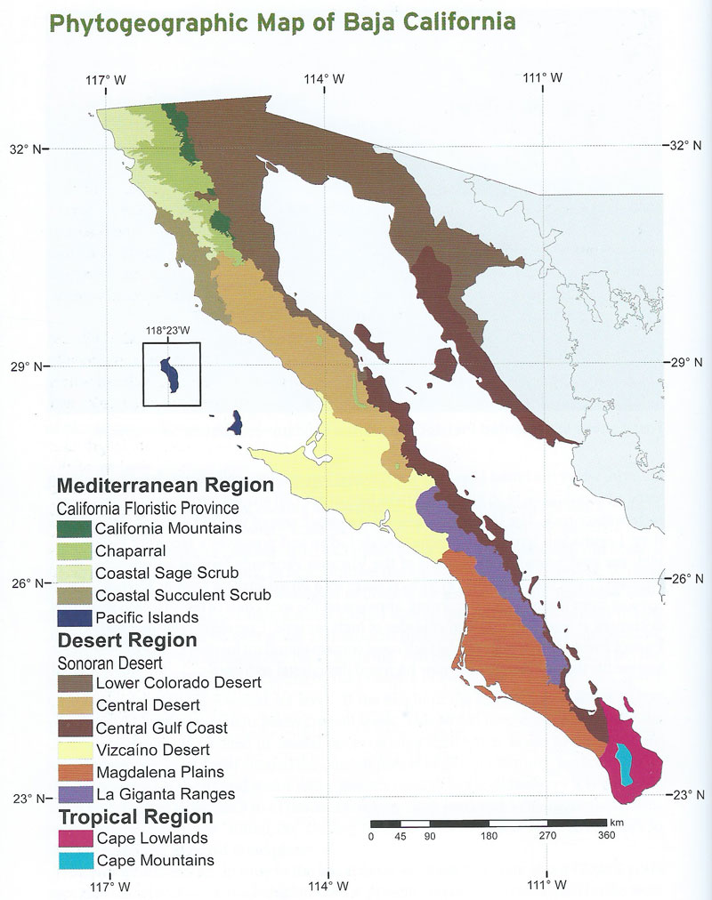
We describe the different regions of Baja California, with particular emphasis on the vegetation, from north to south. These subregions roughly follow the floristic divisions described long ago by Forrest Shreve (1951) and more recent modifications by various authors. A convenient map produced by the San Diego Natural History Museum is here and another link with a cleaner map is here. This latter map is from the Baja California Plant Field Guide by Rebman and Roberts (2012). We purchased it via Amazon prior to our recent trip; I had the original version from 1976. The newest version has much more on the floristic regions and climate etc.
Our focus is heavily on succulent plants, since that is our special interest. Baja California has few to no endemic birds and only a handful of (interesting) reptiles not found elsewhere – but since these are infrequently seen we don’t discuss them. We mention birds in a few locations because they reflect either interesting locations or something not commonly seen. Likewise Baja California is relatively mammal-poor and with no obvious endemics. Baja California really is a place to focus on the flora and landscapes.
Finally, we make no attempt at completeness; this is just an extended blog that should help natural history travelers (including those that may never see the peninsula in person) to benefit from our travels.
Most Baja-bound travelers who are driving come from California or elsewhere in the western US and it is logical to describe the peninsula from North to South. However, in recent decades the huge increase in tourism to Los Cabos has meant that an increasing percentage of foreign (and even Mexican tourists) first experience the Baja California peninsula at the southernmost tip. Only a small percentage of these tourists travel northward to see the rest of the peninsula. We will describe the peninsula from North to South to accommodate the travelers driving from the North, but will have a short, separate section for those not leaving the Los Cabos vicinity.
We have broken down the Baja California peninsula into the following regions. This is simpler than normal floristic depictions, but adequate for the purposes here.
